
Article and photographs by Divi Logan with Assistance from Copilot Smart AI. 31 March 2026.

1. What is a geodetic benchmark? Why are they important?
Most people are familiar with the prefix “geo-“, meaning earth. There is geometry-measuring the earth, and geology- studying that of which Earth is composed and how these materials change. There is geography (literally “earth writing”), which is studying the Earth’s land features and how people interact with the environment, and we have geodesy. This last is a branch of science deals with measuring large portions of the earth, the “art of land surveying.”
A geodetic benchmark is a permanent, precisely surveyed reference point—usually a metal disk or rod—whose exact elevation (and sometimes horizontal position) is known and tied to an official national datum. These marks anchor all mapping, engineering, and surveying work to a stable, shared reference frame.
📍 What a Geodetic Benchmark Is
- A physical marker (often bronze/aluminum disk, rod, or bolt) set into rock, concrete, or a structure.
- Its elevation is precisely determined relative to a vertical datum such as NAVD 88.
- Some also carry horizontal coordinates, making them part of a broader geodetic control network.
- Installed by agencies such as the U.S. Coast & Geodetic Survey / National Geodetic Survey (NGS).
🧭 Why They Matter
- Provide the fixed starting point for all elevation measurements in an area.
- Ensure consistency across engineering projects, maps, and infrastructure surveys.
- Prevent error accumulation in leveling and construction.
- Form the backbone of the national geodetic network, linking local measurements to continental-scale datums.
🛠️ What They Look Like
Most classic benchmarks are:
- 3.5-inch metal disks stamped with:
- Station name
- Agency
- Year set
- Sometimes the exact elevation
- Others are deep-driven rods with protective covers, used where stability is critical.
🗺️ Benchmarks in the Geodetic Network
- A benchmark is one type of survey marker.
- Horizontal control points (triangulation stations) and vertical control points together form a geodetic network.
- These networks allow surveyors to tie any new measurement back to a stable national reference frame.

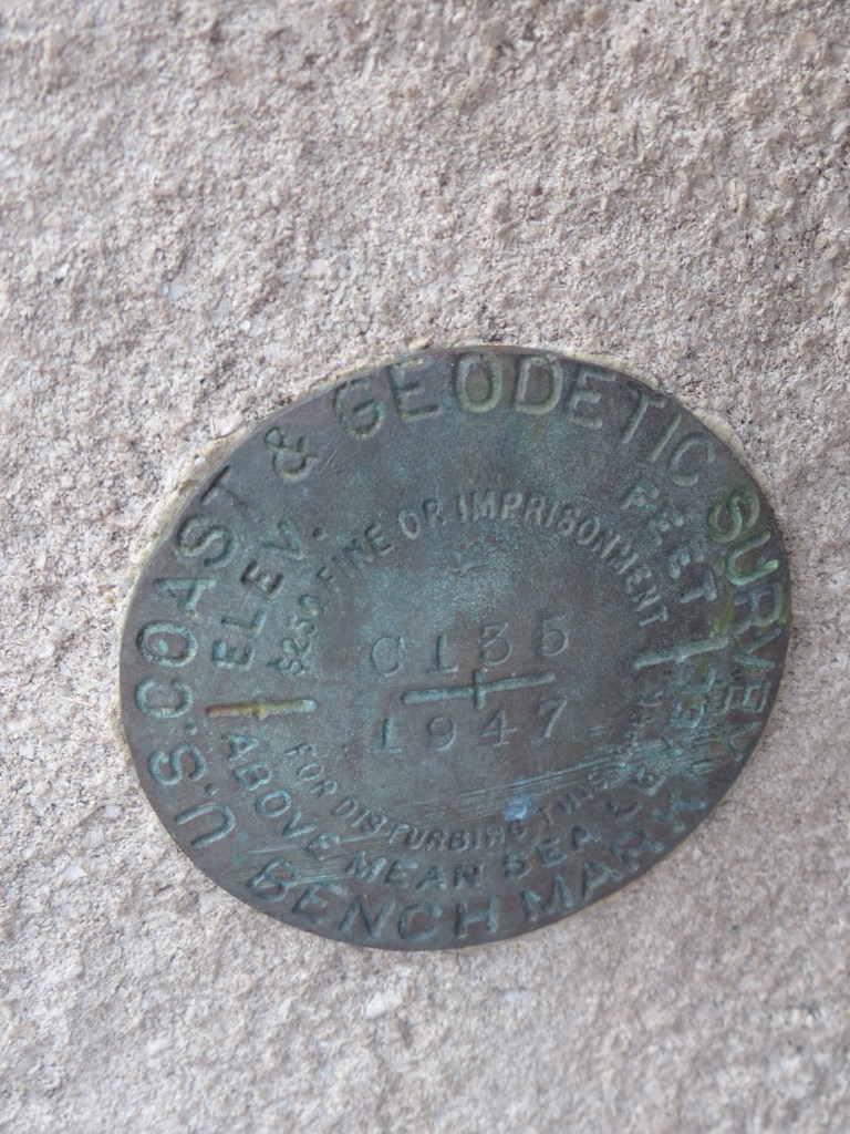
2. Geodetic‑Network Context Note — Station C 135 (PID ME1620) in the Chicago Loop Control Line
The benchmark C 135 (PID ME1620) is part of a mid‑20th‑century USC&GS leveling line that threads through the Chicago Loop, tying the riverfront’s movable bridges, federal buildings, and transportation corridors into a unified vertical control framework. During the 1940s, the U.S. Coast & Geodetic Survey expanded and recalibrated Chicago’s elevation network to support postwar reconstruction, navigation improvements, and the modernization of engineering standards along the Chicago River.
Position within the Loop Control Line
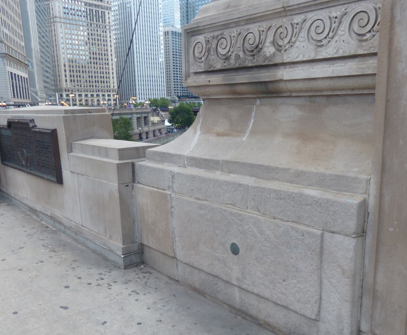
C 135 occupies a strategic point on the northwest bridge tender’s house of the DuSable Bridge, one of the most heavily trafficked and structurally complex bascule bridges in the city. Its placement on a stable limestone base course provided a durable, vibration‑resistant surface—ideal for a benchmark intended to serve as a long‑term reference in a dense urban environment.
Within the Loop, the “C‑series” stations formed a densified vertical spine, linking:
- The Michigan Avenue river crossing
- Adjacent federal and municipal structures
- The river’s navigational control system
- The broader Chicago River datum chain used for dredging, flood control, and bridge engineering
C 135’s adjusted NAVD 88 elevation of 617.32 ft (188.159 m) anchors it firmly within this network, providing a reliable tie between river level, bridge machinery alignment, and the city’s vertical datum infrastructure.
3. Role in the Chicago River Engineering Corridor
Because the DuSable Bridge is both a major transportation artery and a movable structure, precise elevation control was essential. C 135 served as a federally certified reference point for:
- Machinery pit alignment and counterweight calibration
- Monitoring settlement or structural drift in the tender’s houses
- Ensuring consistency between river soundings, dredging operations, and navigation charts
- Coordinating elevation ties during Michigan Avenue streetscape and bridge rehabilitation projects
Its geodetic stability made it a cornerstone for engineering work that required millimeter‑level repeatability.
Integration with National Geodetic Frameworks
As a station with a Permanent Identifier (PID)—a unique alphanumeric code used by the National Geodetic Survey to catalog and retrieve control stations—ME1620 is part of the national geodetic system that underpins mapping, surveying, and infrastructure design across the United States.
- Definition source: Penn State College of Earth and Mineral Sciences, Department of Geography, GEOG 862: GPS and GNSS for Geospatial Professionals, “NGS Control Data Sheets.”
The benchmark’s NAD 83(1986) position and NAVD 88 orthometric height link it to the modern horizontal and vertical datums used by engineers, surveyors, and GIS professionals. Its inclusion in the GEOID18 model further integrates it into contemporary geoid‑based height systems.
Why C 135 Matters in the Loop’s Geodetic Story
C 135 is more than a brass disk on a bridge façade—it is a surviving artifact of the federal geodetic infrastructure that shaped Chicago’s mid‑century engineering landscape. Its presence on the DuSable Bridge ties together:
- The city’s movable‑bridge heritage
- The national vertical datum system
- The Chicago River’s navigation and flood‑control history
- The Loop’s dense network of federal, municipal, and transportation structures
4. Resources
Copilot. Geodetic Control Appendix — DuSable Bridge NW Benchmark C135. Created for the DuSable Bridge Documentation Project, 13 Mar. 2026.
United States Coast and Geodetic Survey. Bench Mark C 135, DuSable Bridge Northwest Tender’s House. U.S. Department of Commerce, 1947.
Harper, Douglas. “Etymology of geodetic.” Online Etymology Dictionary, https://www.etymonline.com/word/geodetic. Accessed 31 March, 2026.
Harper, Douglas. “Etymology of geodesic.” Online Etymology Dictionary, https://www.etymonline.com/word/geodesic. Accessed 31 March, 2026.
Wikipedia contributors. “Geography.” Wikipedia, The Free Encyclopedia. Wikipedia, The Free Encyclopedia, 19 Mar. 2026. Web. 31 Mar. 2026.
Copilot. “Explanation of Geodetic Benchmarks.” Microsoft Copilot, 31 Mar. 2026.
“What Is a Benchmark in Surveying: Definition and Types.” Climb the Ladder, 17 Nov. 2025,
https://climbtheladder.com/what-is-a-benchmark-in-surveying-definition-and-types/?utm_source=copilot.com. Accessed 31 March 2026.
Discover more from Frame the Works
Subscribe to get the latest posts sent to your email.
